Se sei un camminatore, puoi scegliere tra 2 varianti: Itinerario BASSO ed Itinerario ALTO. Il primo attraversa i paesi del fondovalle e presenta un dislivello minore, il secondo privilegia il passaggio in zone montane, con un maggiore dislivello.
I sentieri SAT sono il 300, il 613 e il 627.
Lungo il Cammino San Vili, tra il Lago di Lamar e Bocca Paloni è presente un piccolo tratto di sentiero esposto.
Si ricorda che chi non lo volesse percorrere, può deviare per il facile e breve sentiero n° 615 e successivamente n°611 che dalla loc. Vallene conducono di nuovo sul sentiero San Vili (n°627) poco a valle di Bocca Paloni, sulla via per il Sorasass e Vela/Trento.
As a walker, you can choose between two options: a LOW and a HIGH Itinerary. The first crosses the villages in the valley floor, and is therefore lower and flatter; the second one, instead, walks you through mountainous area passages, generally higher, and requiring more inclined walking.
The SAT trails are 300, 613 and 627.
Along the San Vili Trail, between Lake Lamar and Bocca Paloni, there is a small stretch where the path might seem not fully safe for inexperienced hikers.
However, those who do not wish to walk along it can take two easier and shorter paths – n°615 and then n° 611 – which from Vallene meet up with the San Vili path (n ° 627) just down below Bocca Paloni, on the way to Sorasass and Vela / Trento.
Itinerario BASSO
Lunghezza: 109,2 km
Cammino effettivo: 35 ore circa
LOW itinerary
Length: 109,2 km
Journey: about 35 hours
Number of walking days
I giorni di cammino
Ecco una proposta per organizzare il cammino sull’itinerario “classico”. Proponiamo una versione in 5 giorni, per chi ha voglia di camminare tutto il giorno e due versioni una 6 e una di 7 giorni, per chi vuole avere più tempo per qualche visita. Naturalmente potete personalizzare l’itinerario adattandolo alle vostre esigenze. Consultate la lista delle strutture per pianificare i vostri pernottamenti.
Here travellers can find some ideas about how to organize their walk following the “classic” itinerary. They can choose between a 5 day route, for those who want to walk all day long, or two other options in 6 and 7 days, for those who want to take more time and enjoy some visits. Of course, hikers can customize the itinerary adapting it to their needs. Please, consult the list of facilities to plan your overnight stays.
Cammino Basso 4 giorni
| GIORNO | 1 | 2 | 3 | 4 |
|---|---|---|---|---|
| DA A | MADONNA DI CAMPIGLIO SAONE | SAONE SAN LORENZO IN BANALE | SAN LORENZO IN BANALE MONTE TERLAGO | MONTE TERLAGO/VALLENE TRENTO |
| DISTANZA (km) | 41,7 | 24 | 26,3 | 17.2 |
| TEMPI (ore) | 11 | 7 | 7,5 | 5.5 |
| DISLIVELLO (m) | +394 | +826 | +876 | +543 |
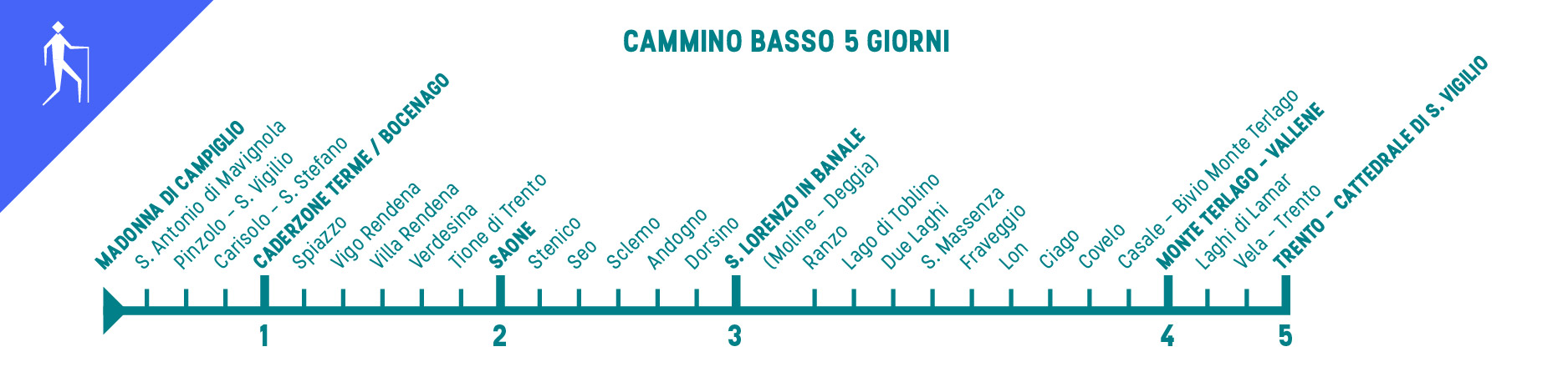
Cammino Basso 5 giorni
| GIORNO | 1 | 2 | 3 | 4 | 5 |
|---|---|---|---|---|---|
| DA A | MADONNA DI CAMPIGLIO CADERZONE TERME/BOCENAGO | CADERZONE TERME/BOCENAGO SAONE (via Tione di Trento) | SAONE SAN LORENZO IN BANALE | SAN LORENZO IN BANALE MONTE TERLAGO/VALLENE | MONTE TERLAGO/VALLENE TRENTO |
| DISTANZA (km) | 22,1 | 19,6 | 24 | 26.3 | 17.2 |
| TEMPI (ore) | 6 | 5,5 | 7 | 7,5 | 5.5 |
| DISLIVELLO (m) | +159 | +235 | +826 | +876 | +543 |
Cammino Basso 6 giorni
| GIORNO | 1 | 2 | 3 | 4 | 5 | 6 |
|---|---|---|---|---|---|---|
| DA A | MADONNA DI CAMPIGLIO CADERZONE TERME/BOCENAGO | CADERZONE TERME/BOCENAGO SAONE (via Tione di Trento) | SAONE STENICO | STENICO SANTA MASSENZA | SANTA MASSENZA MONTE TERLAGO/VALLENE | MONTE TERLAGO/VALLENE TRENTO |
| DISTANZA (km) | 22,1 | 19,6 | 13,2 | 27,1 | 10 | 17,2 |
| TEMPI (ore) | 6 | 5.5 | 4 | 7,5 | 4 | 5.5 |
| DISLIVELLO (m) | +159 | +235 | +424 | +692 | +856 | +543 |
Cammino Basso 7 giorni
| GIORNO | 1 | 2 | 3 | 4 | 5 | 6 | 7 |
|---|---|---|---|---|---|---|---|
| DA A | MADONNA DI CAMPIGLIO S.ANTONIO DI MAVIGNOLA | S.ANTONIO DI MAVIGNOLA SPIAZZO | SPIAZZO SAONE | SAONE DORSINO | DORSINO SANTA MASSENZA | SANTA MASSENZA MONTE TERLAGO/VALLENE | MONTE TERLAGO/VALLENE TRENTO |
| DISTANZA (km) | 7,1 | 18,5 | 16,1 | 22,2 | 16,9 | 10 | 17,2 |
| TEMPI (ore) | 2 | 5 | 4,5 | 6,5 | 5 | 4 | 5,5 |
| DISLIVELLO (m) | 0 | +279 | +115 | +733 | +375 | +586 | +543 |
Itinerario ALTO
È un percorso alternativo, con maggiore dislivello in quanto, rispetto alla proposta dell’Itinerario BASSO, presenta due varianti in quota (da Vigo Rendena a Ragoli passando per Larzana e da Ranzo a Ciago passando per Margone).
Lunghezza: 110 km
Cammino effettivo: circa 40 ore
HIGH itinerary
It is a more challenging itinerary with a greater difference in height. There are two variants: the first one from Vigo Rendena to Ragoli, walking through Larzana, and the second one from Ranzo to Ciago walking through Margone.
Length: 110 km
Journey: about 40 hours
Number of walking days
I giorni di cammino
La nostra proposta per il primo giorno è di partire da Madonna di Campiglio e raggiungere località Pra de la Casa (2 h e 1/2 circa, su tracciato alternativo al Cammino San Vili tradizionale. Il percorso è pensato per 5 giorni di cammino, impegnativi in termini di ore di percorso e dislivello, ma è possibile “spezzare” il viaggio adattandolo alle esigenze di ciascun camminatore. Contattate le strutture accreditate per verificare la disponibilità di posti letto per il pernottamento.
Our proposal for the first day is to start from Madonna di Campiglio and reach Pra de la Casa (about 2 h and ½) on an alternative route to the traditional San Vili Path. The itinerary, designed for a 5 day walking, is challenging in terms of walking hours and difference in altitude, but it is possible to “break up” the trip adapting it to the needs of each walker. Please, contact the accredited facilities to check bed availability for overnight stays.
Cammino Alto 5 giorni
| GIORNO | 1 | 2 | 3 | 4 | 5 |
|---|---|---|---|---|---|
| DA A | MADONNA DI CAMPIGLIO CADERZONE TERME/BOCENAGO | CADERZONE TERME/BOCENAGO MONTAGNE (TRE VILLE) | MONTAGNE (TRE VILLE) SAN LORENZO IN BANALE | SAN LORENZO IN BANALE MONTE TERLAGO/VALLENE | MONTE TERLAGO/VALLENE TRENTO |
| DISTANZA (km) | 22,1 | 20,8 | 25,7 | 24,9 | 17,2 |
| TEMPI (ore) | 6 | 7,5 | 7,5 | 7,5 | 5.5 |
| DISLIVELLO (m) | +159 | +968 | +819 | +892 | +543 |
Cammino Alto 6 giorni
| GIORNO | 1 | 2 | 3 | 4 | 5 | 6 |
|---|---|---|---|---|---|---|
| DA A | MADONNA DI CAMPIGLIO CADERZONE TERME/BOCENAGO | CADERZONE TERME/BOCENAGO MONTAGNE (TRE VILLE) | MONTAGNE (TRE VILLE) DORSINO | DORSINO MARGONE | MARGONE MONTE TERLAGO | MONTE TERLAGO/VALLENE TRENTO |
| DISTANZA (km) | 22,1 | 20,8 | 23,9 | 14,9 | 11,8 | 17,2 |
| TEMPI (ore) | 6 | 7,5 | 7 | 4,5 | 3,5 | 5.5 |
| DISLIVELLO (m) | +150 | +968 | +726 | +584 | 401 | +543 |